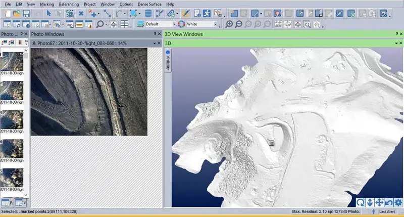
Eos Systems has released PhotoModeler UAS, a new version of PhotoModeler aimed at those using UAVs for generating surface models, orthophotos, or volume measurements. It offers UAS-focused processing (ability to handle GPS data from your UAV to improve accuracy and speed), Volume Objects (allows to model and measure stock piles or other similar terrain shapes, and obtain accurate volumes), multi-spectral image support, Geographic Coordinate Systems, create minor contours with a different look than major contours, etc.
A new version of PhotoModeler standard has also been released. New features in v2016.1 include:
- Locate function – more easily find 3D imported points and 3D project points on photos before they have been marked using new Locate and Find Projected functions
- Photo-texturing improvements – quality textures are generated only once and have higher resolution (map per mesh now instead map per project)
- UI speed improvements
- Orthophoto quality improvement – orthophotos have a new subpixel method to give higher quality (as seen at higher zooms)
- Background check for updates – once per day (under user control) PhotoModeler will check for any updates available and inform you
- Auto-calibration improvements (scanner) – camera auto-calibration has been improved and made more stable providing better camera calibrations in more cases
PhotoModeler Motion is being retired and its capability for tracking 3D objects over time will be rolled into both PhotoModeler Scanner and PhotoModeler UAS. PhotoModeler is now offered in three versions: the base PhotoModeler software ($1145), PhotoModeler Scanner ($2495) which adds SmartMatch scanning and dense surface modeling, and the new PhotoModeler UAS ($3495). The update costs $445 for owners of previous versions of PhotoModeler and is free for current customers on an active maintenance subscription. A trial version is available for download. More on PhotoModeler’s site.


