
Maproom released
Nov 05, 2016 by CGPress Staff
1
|
(Updated) A coupon code is available that reduces the price by €100 until the end of the year. The code is: maproomlaunch2016.
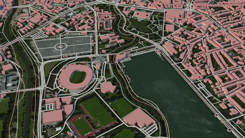
Klaas Nienhuis’ script for quick creation of maps and topography from online data is now available. The script works entirely inside 3DS Max and alleviates the need to download and process datasets in an external application. Features include:
Klaas Nienhuis’ script for quick creation of maps and topography from online data is now available. The script works entirely inside 3DS Max and alleviates the need to download and process datasets in an external application. Features include:
- The ability to create terrains from global datasets from city scale to world scale with SRTM1, SRTM3 and ETOPO
- The ability to use satellite images from many sources such as Bing, Mapbox or DigitalGlobe
- The ability to add OSM vector data to your map. For instance buildings, roads, parks or rivers
- Tools to convert OSM shapes to actual believable 3D models instantly with the built in stylesheets, or create your own stylesheets
- The ability to import your own shapefiles or use the excellent shapefiles from Natural Earth to get global shapes such as country borders, largest cities in the world or all major airports
- Geocoding support. No need to use lon/lat coordinates. Just type an address and let Maproom sort it out
- Ability to change map projections. Don’t like Mercator? Use one of the many other map projections including UTM, Mollweide and equidistant cylindrical. UTM is useful if you need to match the map with city plans or architectural drawings.
- Autoload maps when zooming in or out without downloading millions of images at high resolution
- Ability to reliably measure distances on a map
Source: Klaas Nienhuis


Great tool. Pricey but worth every penny.