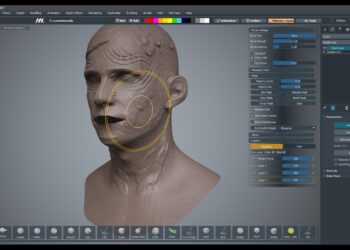
Epic Games has updated RealityScan, its 3D scanning software, with new automation systems and expanded LiDAR functions. Version 2.1 introduces tools aimed at reducing manual steps and broadening data integration options.
The release adds expanded automation support, accompanied by new documentation on the Epic Developer Community. Material covering Command Line Interface usage, templating and sample projects outlines how to automate data extraction, format results and generate reports. The templating system replaces the previous reporting framework and is designed to streamline repetitive processes. New REST and gRPC plugins include Python samples and full Linux support, enabling the software to connect across multiple machines. Example projects show how to run servers and clients for both communication protocols and how to produce structured outputs such as JSON files.
RealityScan 2.1 broadens LiDAR-based workflows with support for SLAM data import, including trajectories, images and point clouds. Merging SLAM data with photogrammetry or terrestrial laser scans provides live positional tracking during capture and can help address surfaces that present challenges for photogrammetric reconstruction. The update adds support for classified point clouds in LAS and LAZ formats, which can improve mesh quality, reduce processing through selective meshing and filter unwanted objects.
The version introduces further updates such as new export options for registration in OpenCV format, the ability to render from camera positions with matching distortion and a colored checker map for UV inspection and refinement.
To find out more, visit the Epic Games website.


